This is the first in a series of posts that differ from the usual format in not being about journeys in East Anglia. This time the landscape is still flat, but in the future hills will probably make an appearance as well. There’s no reason to worry though, as I still have a long list of trips I want to make in the East of England.
I recently stayed in Berlin for a week, and wanted to go for a walk in the countryside surrounding the city. Berlin is quite a good base for someone with my tastes: The writer Thedodor Fontane, for instance, was apparently motivated to write his “Rambles in Brandenburg” about the neighbouring federal state because it was perceived to be one of the least interesting parts of the whole country. I preferred to venture somewhat further afield though to Mecklenburg-Vorpommern, which I think can justly be regarded as the East Anglia of Germany: It is flat, rural, remote, and has lots of water.
Initially I had planned a walk between the two seaside towns of Warnmünde and Graal-Müritz on the Baltic coast, however this could not be implemented since bus replacement services would have made the already very long journey unfeasible. Instead it was decided to go to the island of Usedom, a popular holiday destination. I had already been there once a couple of years ago with C. It had been an extremely hot summer and staying in the city was not enjoyable, so we decided to go to the seaside and stay there overnight on the beach – with only our sleeping bags and no tent, as there had not been any rain in weeks. Unfortunately this changed at around 5am, when we were rudely awoken by a massive downpour, and had to walk through the flooded streets of Zinnowitz to the railway station. There we caught the first (heavily air-conditioned) train for the three-hour journey back to Berlin, and, in our wet clothes, were probably the only people in the city who thoroughly enjoyed the high temperatures.
Despite this memorable precedent C. accompanied me again this time, and soon we were on the branch line to Usedom. We disembarked at the village Kölpinsee, where tiny roads and cul-de-sacs have grandiose names, such as German union street (Straße der Deutsche Einheit) and Diplomat’s way (Diplomatenweg) (only one house).

Thatched roofs are very common on the island, and we came across a good number of them. Not only that, we also walked past the home of a thatcher, which was quite the coincidence since the night before we had watched a documentary about life on Usedom in which that very thatcher was being portrayed, and had talked about how much he enjoys working with the material reed.

We soon reached the end of the village, which was marked by a very German fish restaurant with a humorous weather station:

(Wet stone: rain, white stone: snow, dry stone: sun, shaking stone: wind, invisible stone: fog, stone on the ground: end of the world).
We continued through fields until we reached a place called Loddiner Höft on the southern coast of the island. The views were pleasant, and unlike on the northern site the water here is very still as it is part of a lagoon.

I had bought a map for this walk, however I was not very happy with it as it was not detailed enough, and there were real-life paths that were not shown on it, while other paths that were shown could not be recognised in the real world. According to this map we would have to double-back to where we came from in order to continue our walk, but we saw a well-trodden way through the forest which, so we hoped, would surely also lead us to our destination. Why would it be frequently used if it were a dead end, after all?
We therefore followed the path, which was quite steep at times:

Soon an alternative explanation for the popularity of the path was found though: It ends at a remote beach. On the one hand this was disappointing as we now had to walk back for an even longer time, but on the other hand we had found the perfect spot for lunch.

After that we walked and, for the steep parts, scrambled back to the fish restaurant, from were we headed towards the slightly larger town of Koserow. On this stage of the walk the resemblance to the landscape of East Anglia, in particular some areas in Norfolk, was particularly striking, so I felt very much at home.


On the way we also saw a quaint traditional oven, which I think is used for baking bread: 
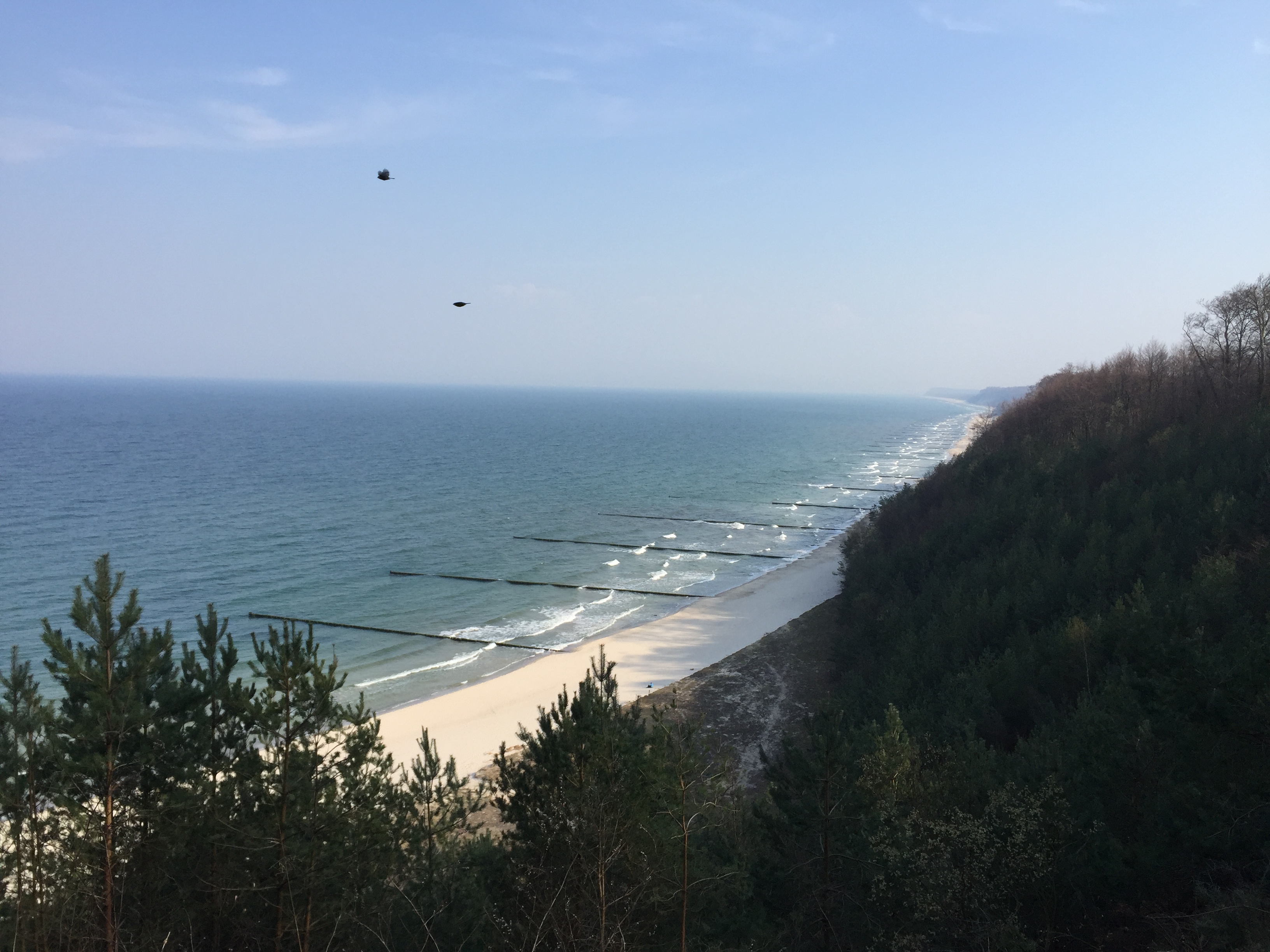
In the town we stopped for a coffee break to prepare for for the final part of the walk: The ascent of the Streckelsberg, which with 58 meters is the third-highest hill on Usedom. Overall the hill is dominated by a forest, and one disadvantage of trees is of course that they tend to block the view. Nevertheless there were some spots from which we could enjoy the northern coast of the island, as can be seen in the header image. After descending we walked west along the beach to the village of Zempin, from where we intended to take the train back home.

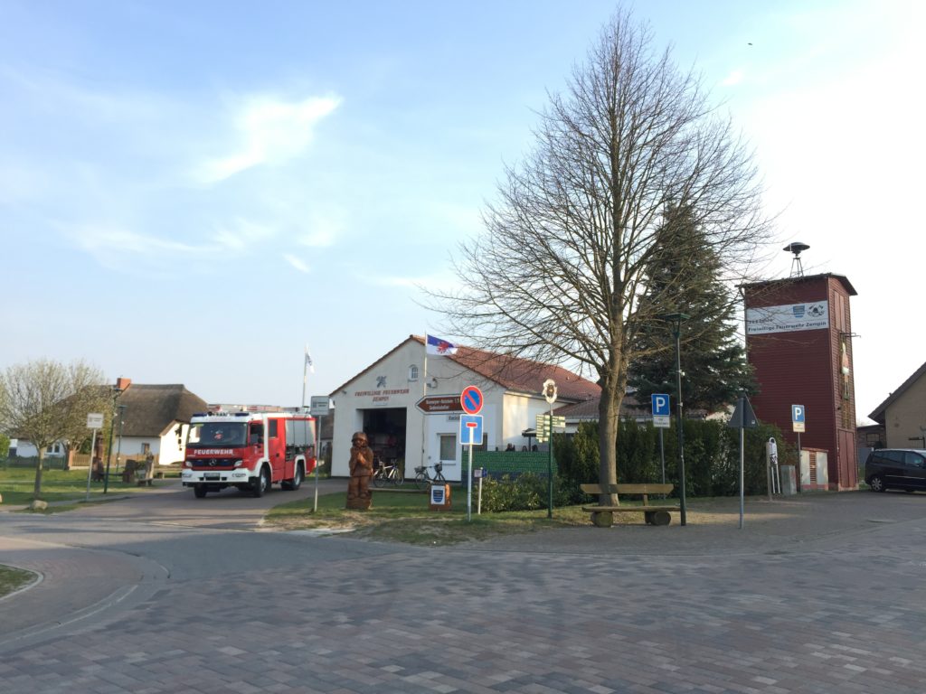
Our timing was not ideal, for as we arrived at the railway station the next train was in 40 minutes. To pass the time we walked through the quiet village, wondering how many of the houses are holiday homes, and how many have permanent residents. As in so many other German villages the centre of the social life seemed to be the house of the volunteer fire department – which may seem odd, but is pretty standard.
Usedom is so narrow at this point that after about 15 minutes we had again reached the southern end, so we turned around and walked back to the station. Overall this journey can be counted as a success: Flat walks are possible in Germany, and unlike the last time we stayed dry until the end. I therefore plan to explore to Mecklenburg-Vorpommern more in the future.
Really enjoy your posts, in part because I’m something of a flat landscape and railway enthusiast myself. Speaking of which, I thought I’d make some recommendations of very flat, water-ridden and slightly remote areas:
– The Nordfriesland coastal area in Schleswig-Holstein, and the Eiderstedt peninsula in particular. Quite accessible by train as well. If possible, visit one of the tiny ‘halligs’ in the Wadden Sea.
– The most northerly part of the Dutch-German border region, known on either side by its historic name R(h)eiderland. Very barren in places, but strangely beautiful in my opinion. Somewhat less easily accessible by train, but it is doable. Take the train from Weener to Groningen and disembark at Bad Nieuweschans. The ‘Kiekkaaste’ provides for a nice view over the Ems-Dollart estuary.
– The southwestern corner of the Dutch province of Friesland (roughly everything to the southwest of Sneek). Abounds with lakes, small waterways and picturesque villages. Accessible via the Leeuwarden – Stavoren railway line.
Best wishes,
Stefan
Hi Stefan,
thanks for these suggestions which all sound great, especially the marshy Eiderstedt peninsula should be just my cup of tea. Unfortunately I am rarely ever in the north of Germany, so paying them a visit will be difficult in the near future. I will however be in the Netherlands in July (although more in the south), and hope to do some flatness-sightseeing then!